Agricultural drone technology is therefore part of the wider precision-agriculture ecosystem. It can work alongside satellite imagery, soil sensors, GPS equipment, weather information, geographic information systems, and farm-management platforms.
The technology exists primarily to make field observation more systematic and to help farmers gather information about large or difficult-to-access areas.
Why Agricultural Drones Matter Today
Indian agriculture includes farms of many different sizes, crops, terrains, and production systems. Manual field inspection can require considerable time, particularly when farmers need to monitor crop conditions across multiple plots.
Drones can provide an aerial perspective that complements ground inspection.
Potential applications include:
Crop health observation
Field mapping
Plant population assessment
Irrigation planning
Identification of stressed areas
Pesticide and nutrient application
Crop-growth documentation
Agricultural research
Disaster or weather-impact assessment
Precision agriculture experiments
The technology is particularly relevant where timely information matters. Aerial imagery can help identify differences between sections of a field that may not be immediately visible from ground level.
However, drones are not a replacement for agronomic knowledge. Images and sensor data still need appropriate interpretation, while spraying decisions should follow crop-specific recommendations and applicable agricultural rules.
Major Types of Agricultural Drones
Agricultural drones can generally be grouped according to their primary function.
| Drone type | Main purpose | Typical technology |
|---|---|---|
| Mapping drone | Field surveying and mapping | RGB camera, GPS, RTK |
| Monitoring drone | Crop observation | RGB or multispectral camera |
| Spraying drone | Liquid application | Tank, pump, nozzles |
| Multispectral drone | Crop-health analysis | Multispectral sensors |
| Research drone | Experimental agriculture | Specialized sensors |
| Hybrid platform | Multiple agricultural tasks | Modular payloads |
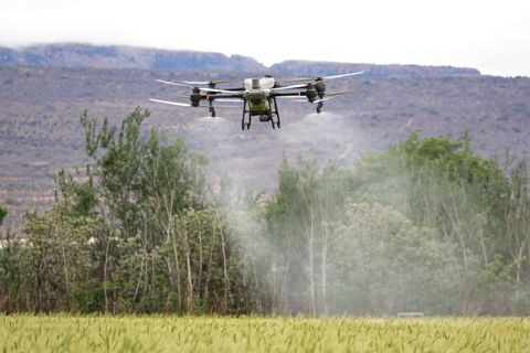
Agricultural spraying drones are receiving particular attention because they can distribute liquid inputs over defined areas while maintaining a relatively consistent flight path.
Application settings should nevertheless be determined according to crop, chemical label requirements, weather conditions, nozzle characteristics, and relevant agricultural guidance.
Agricultural Drone Mapping
Agricultural drone mapping creates aerial representations of fields that can be used for measurement and analysis.
A mapping workflow commonly involves:
Planning a flight boundary.
Establishing appropriate flight altitude and overlap.
Capturing aerial images.
Processing the images through specialized software.
Creating an orthomosaic or other map.
Reviewing field patterns and measurements.
Combining the results with ground observations.
High-accuracy systems may use RTK or similar positioning technologies.
Mapping can support activities such as field-area measurement, drainage assessment, crop monitoring, irrigation planning, and identification of visibly different crop zones.
Agricultural Drone Software
Agricultural drone software is the digital component that connects flight planning, imagery, mapping, data processing, and analysis.
Depending on the platform, software may provide:
Automated flight planning
Route generation
Image stitching
Orthomosaic creation
Field boundary mapping
Vegetation-index calculations
3D modelling
Measurement tools
Data export
Flight-log management
Software should be selected according to the drone, camera or sensor, operating system, and intended agricultural application.
For example, software designed for basic RGB photography may not provide the analytical functions required for multispectral crop assessment.
Agricultural Spraying Drones
Spraying drones use tanks, pumps, nozzles, controllers, and flight systems to distribute agricultural liquids.
Their performance can depend on several variables:
Tank capacity
Nozzle configuration
Droplet characteristics
Flight speed
Flight height
Wind conditions
Terrain
Battery capacity
Pump output
Crop canopy
Weather conditions are especially important. Wind can affect spray drift and distribution, while unsuitable conditions may create safety and application problems.
Farm operators should always follow the relevant product label, agricultural authority guidance, and drone operating requirements rather than assuming that aerial application is appropriate for every crop or chemical.
Agricultural Drone Price: What Determines the Figure?
When researching agricultural drone price, the displayed figure should not be viewed in isolation.
Different agricultural drones have substantially different configurations. Factors influencing the overall financial requirement can include:
Payload capacity
Battery quantity
Charging equipment
Camera or sensor type
RTK positioning
Spray equipment
Mapping software
Training requirements
Maintenance arrangements
Replacement components
Data-processing requirements
A basic observation drone and a high-capacity spraying platform serve different purposes and therefore should not be compared only by their headline figures.
A useful comparison table should record the complete specification.
| Feature | Questions to examine |
|---|---|
| Payload | What equipment can the drone carry? |
| Flight time | How long can it operate per battery cycle? |
| Navigation | Does it support GPS, RTK, or other positioning? |
| Camera | RGB, multispectral, thermal, or another sensor? |
| Spray system | What tank and nozzle configuration is available? |
| Software | What mapping and analysis functions are supported? |
| Training | What pilot training is required? |
| Safety | What obstacle and return-to-home features are included? |
Agricultural Drone Manufacturers and Suppliers
The Indian agricultural-drone ecosystem includes domestic manufacturers, technology companies, agricultural institutions, training organizations, and equipment distributors.
When researching agricultural drone manufacturers, specifications should be verified rather than relying solely on promotional descriptions.
Useful information to check includes:
Drone category
Type certification status where applicable
Registration requirements
Payload specifications
Battery specifications
Operating limitations
Software compatibility
Training arrangements
Maintenance documentation
Warranty conditions
The same principle applies when researching agricultural drone suppliers. The supplier's documentation should clearly identify the actual drone model and its regulatory status.
Government procurement or agricultural-department programs may also have separate eligibility and empanelment requirements.
Agricultural Drone Training
Safe operation depends heavily on pilot knowledge.
Agricultural drone training can cover:
Flight fundamentals
Airspace awareness
Pre-flight inspection
Emergency procedures
Battery management
Navigation
Agricultural payload operation
Weather assessment
Safety procedures
Data collection
Applicable regulations
DGCA's framework provides for Remote Pilot Training Organizations, and official DGCA guidance states that applicable drone operations require an appropriate Remote Pilot Certificate. Pilots are also expected to check airspace before flight and follow the requirements associated with the relevant operating zone.
Recent Agricultural Drone Developments in India
Government support for agricultural drone adoption continued to develop during 2025 and 2026.
On April 4, 2025, the Ministry of Agriculture and Farmers Welfare stated that the Sub-Mission on Agricultural Mechanization supports demonstrations of Kisan Drones, individual acquisition by farmers, and Custom Hiring Centres for agricultural drone operations.
On July 8, 2025, the ministry reported the release of crop-specific Standard Operating Procedures for applying soil and plant nutrients through drones. This represents an important move toward more crop-specific operational guidance.
On December 16, 2025, the government highlighted drones, artificial intelligence, precision agriculture, climate-smart agriculture, and related technologies as part of its broader agricultural technology initiatives.
On February 13, 2026, the government reported that 1,094 drones had been distributed to selected Women Self Help Groups through the wider Namo Drone Didi initiative, with participating members receiving pilot training through DGCA-authorized training organizations.
On March 24, 2026, the government reiterated the Namo Drone Didi framework, including an overall allocation of ₹1,261 crore for the 2023–24 to 2025–26 period and central financial assistance covering up to 80% of the drone package for eligible women SHGs, subject to the scheme's conditions.
More recently, on August 11, 2026, the government described precision agriculture as an important research area, with ICAR's Network Program on Precision Agriculture incorporating sensors, remote sensing, drones, satellites, AI, and information technologies.
Laws and Policies Affecting Agricultural Drones
Agricultural drone operations in India are primarily governed by the country's civil-aviation drone framework.
The Drone Rules, 2021 establish requirements covering drone operations in India. DGCA remains the principal aviation regulator for applicable drone requirements.
Important operational principles include:
Use of applicable type-certified and registered drones
Appropriate Remote Pilot Certificate requirements
Airspace checking before flights
Compliance with Green, Yellow, and Red Zone requirements
Visual Line of Sight requirements where applicable
Pre-flight safety checks
Maintenance according to manufacturer instructions
Respect for privacy and public safety
DGCA's current public guidance states that Yellow and Red Zone operations require the applicable permissions, while Green Zone operations can proceed without such permission when all other rules are followed. It also states that BVLOS operations require specific approval.
Agricultural programs are also connected with the Sub-Mission on Agricultural Mechanization, which supports demonstrations, training, testing, Custom Hiring Centres, and agricultural mechanization initiatives.
Tools and Useful Resources
Several resources can help farmers, researchers, operators, and agricultural organizations understand drone technology.
DGCA: Current aviation rules, guidance, pilot requirements, and regulatory information.
Digital Sky: Airspace and drone-related regulatory information.
Bharat Kisan Drone resources: Information associated with agricultural drone initiatives.
ICAR: Research and agricultural technology information.
Krishi Vigyan Kendras: Agricultural demonstrations and capacity-building resources.
GIS and mapping software: Field measurement and spatial analysis.
Drone flight-planning applications: Route and mission planning.
Weather applications: Wind, rainfall, and visibility monitoring.
Agricultural record templates: Document crop, field, flight, and application information.
Battery and maintenance logs: Track operating cycles and equipment condition.
Before conducting a flight, operators should verify current DGCA requirements because aviation rules, permissions, and technical guidance can change.
Practical Agricultural Drone Checklist
Before using a drone in farming, consider:
Define the agricultural objective.
Select the appropriate drone type.
Check the drone's regulatory status.
Verify the pilot's qualifications.
Check the Digital Sky airspace information.
Inspect batteries and aircraft components.
Review weather conditions.
Establish safe operating boundaries.
Prepare an emergency procedure.
Record flight and application information.
Follow crop-specific agricultural guidance.
Protect personal and farm data.
Frequently Asked Questions
What are farming drones used for?
Farming drones can be used for field mapping, crop monitoring, aerial imaging, agricultural spraying, plant-health assessment, and research. The appropriate application depends on the drone's payload and software.
What affects agricultural drone price?
Payload capacity, sensors, batteries, positioning technology, spray equipment, software, training, and other technical specifications can influence the overall financial requirement.
Are agricultural spraying drones legal in India?
Agricultural spraying is possible within India's drone regulatory framework, but the aircraft, pilot, operating location, agricultural application, and other applicable requirements must comply with current rules and guidance.
Is agricultural drone training required?
Applicable drone operations can require an appropriate Remote Pilot Certificate and training through authorized organizations. DGCA's current guidance should be checked for the specific drone category and operation.
What is agricultural drone mapping?
It is the process of capturing aerial images or sensor data and processing them into maps or analytical outputs that can help evaluate field boundaries, crop conditions, terrain, and other agricultural characteristics.
Conclusion
Agricultural drones are becoming an important component of precision agriculture in India. Farming drones can support mapping, crop observation, spraying, data collection, and research when used with suitable equipment and agricultural knowledge.
Developments during 2025 and 2026 show continued government attention to Kisan Drones, precision agriculture, pilot training, crop-specific operating procedures, and women-led rural drone initiatives.
For anyone researching agricultural drones, the most useful approach is to look beyond the aircraft itself. Drone specifications, sensors, mapping software, pilot training, airspace rules, agricultural guidance, maintenance procedures, and data management all contribute to effective operation.
As the technology develops, combining aerial information with ground observations, satellite data, sensors, and agronomic expertise is likely to remain central to responsible precision farming.